
Road trips are great for spontaneous holidays, but it’s important to budget for fuel costs. Here are the best fuel saving tips for road trips and long drives.
Victoria

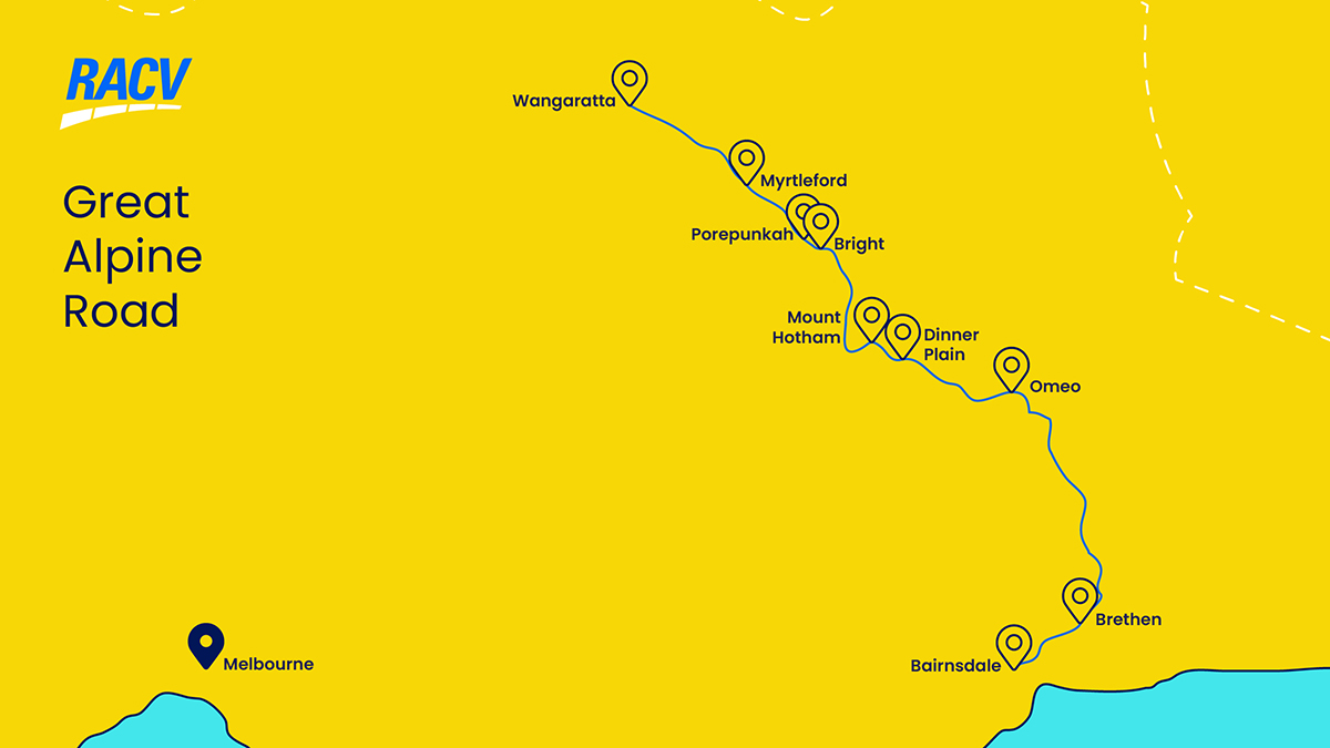
The Great Alpine Road in Victoria: itinerary and rest stops
Australia’s highest year-round accessible sealed road, Victoria's Great Alpine Road is one of the country’s most scenic and rewarding drives.
Stretching more than 300km from Wangaratta to Bairnsdale, this epic road trip winds through alpine peaks, cool-climate wine country, historic gold towns and lush rainforest valleys. Whether you’re chasing snow in winter, wildflowers in spring, or gourmet produce and pristine nature in summer and autumn, the Great Alpine Road delivers an unforgettable journey through the heart of Victoria's High Country.
The Great Alpine Road can be tackled in either direction - north to south (Wangaratta to Bairnsdale), or in reverse. Many travellers choose the Wangaratta to Bairnsdale route for a steady climb into the mountains before descending toward the coast.
Allow at least three days to complete the drive, with time to linger in charming towns, hike alpine trails and enjoy farm-to-table dining.
Are you road trip ready?
Before you embark on your adventure, ensure that your car is prepared and safe for your road trip, pack an emergency car safety kit, and update your emergency roadside assistance plan. Download the VicEmergency app to your phone to check for official bushfire and extreme weather warnings.
Electric car owners are also advised to check EV charging availability along the route prior to leaving. RACV Members can access information about EV charging stations via the RACV App.
Why not tackle the Great Alpine Road for your next Victorian road trip?
The best stops along Victoria's Great Alpine Road
Wangaratta
Your Great Alpine adventure begins in Wangaratta, a regional city with a rich cultural heritage.
Pop into the pretty Wangaratta Art Gallery for showcases of textile artworks and small sculptures or go hiking in the Warby-Ovens National Park nearby. In summer, visit Sydney Beach from the eastern end of Ovens Street to swim at a sandy bend near a weir on the Ovens River.
If you're a keen cyclist, the Murrray to Mountains Rail Trail stretches for 100 kilometres between Wangaratta to Harrietville, with branches out to Milawa, Beechworth, Yackandandah and Wandiligong.
Enjoy a meal at once of many local cafes and bistros, then enjoy some cool-climate wines from the vast number of wineries around Rutherglen and Milawa, both an easy drive away.
Myrtleford
- Distance: 48km
- Time: 40 minute drive
Heading east from Wangaratta, the road passes through farmland and forest before arriving in Myrtleford, a town nestled beneath the peaks of the Ovens Valley. Known for its strong Italian heritage, Myrtleford has built a reputation for good food, local wine and a welcoming atmosphere. The town comes especially alive in autumn with the La Fiera festival, celebrating Italian culture through food, music and family-friendly events.
The town’s charm lies in its rural simplicity. Enjoy wood-fired pizza or fresh gnocchi at one of several Italian eateries, or sip wine from nearby vineyards like Gapstead Wines, which offers panoramic views over the valley. Michelini Wines offers Italian grape varietals if you'd like to continue the Italian heritage flavour of Myrtleford. Purchase some local produce for the road at the monthly Myrtleford Farmers Market, held on the fourth Saturday of each month.
Nature lovers will enjoy walking up Reform Hill to a lookout offering sweeping views over the town and surrounding ranges. Or drive south about 20 kilometres to Lake Buffalo, a broad expanse of water bordered by gorgeous mountains. Have a picnic near one of the gas BBQs, go fishing year round, or paddle in the water if it's warm enough.
Porepunkah
- Distance: 25km
- Time: 20 minute drive
Welcome to Porepunkah, the gateway to Mount Buffalo National Park. Access the national park via Mount Buffalo Road from Porepunkah, which winds through several day visitor areas and camping areas. You'll want to stop at Eurobin Creek, Rollasons Falls, The Gorge, Lake Catani, Dingo Dell, The Cathedral, Cresta Valley and The Horn. Each area offers beautiful alpine hikes, often with wonderful granite tors, mountain waterfalls, tall snow gums, spring wildflowers, and awe-inspiring lookouts over the region.
Head to Lake Catani, one of Victoria's best freshwater swimming holes, to swim in clear water in this grand alpine landscape. There's good wild-bred rainbow trout fishing to be had here, with a small jetty onsite. A small beach provides easy kayak launching, while the toilets, BBQs and picnic tables offer a lovely place for lunch outdoors. The Lake Catani Campground makes for a great overnight in warmer weather.
In winter, grab your toboggan and head to Dingo Dell. This is a great place for snow play, complete with a gentle slope for tobogganing that's topped by the Dingo Dell Lookout for views across the plateau. Cross-country skiiers can find great trails at Cresta Valley nearby.
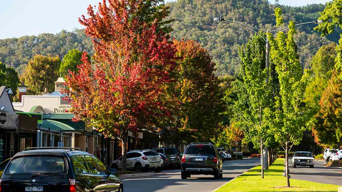
Bright
- Distance: 7km
- Time: 10 minute drive
Continuing along the Great Alpine Road, the next stop is Bright, arguably the crown jewel of Victoria's alpine towns. Framed by the towering slopes of Mount Buffalo National Park, Bright is renowned for its vibrant scenery, boutique shops, fine dining and outdoor adventure opportunities.
Bright's town centre is a lively hub where cafes, pubs and galleries draw visitors throughout the year. During warmer months, the river that Bright sits near becomes a popular spot for swimming, kayaking and picnicking. Don't miss the Ovens River Canyon Walk, a 6km loop that follows the Ovens River and crosses over picturesque suspension bridges. There's a shorter 3km version if you prefer.
Wet your whistle with some quirky craft beers at Bright Brewery (complete with a full brewpub menu, guided brewery tours, live music, trivia nights and more) or with local cider at Nightingale Bros' apple orchards.
Autumn is particularly magical in Bright, when the trees lining its streets explode in hues of red, gold and orange during the Bright Autumn Festival in April and May. But each season brings something special: mountain biking and paragliding in summer, fiery foliage in autumn, snow access and the Darker Days beer festival in winter, and wildflowers in spring.
The Great Alpine Road travels straight through Bright. Image: Visit Victoria
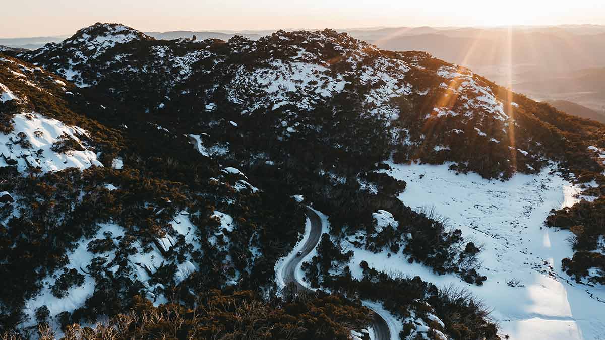
Mount Hotham
- Distance: 55km
- Time: 1 hour drive
On your way from Bright to Mount Hotham, look out for the small township Smoko en route. This town is appropriately named after the large tobacco farms that used to line the road and Ovens River.
You'll then pass through Harrietville, a quaint former gold mining town set in a narrow alpine valley. Surrounded by forest and flanked by the east and west branches of the Ovens River, Harrietville is a peaceful spot worth a pitstop. Head to Tronoh Dredge just outside town for a short walk or swim.
From Harrietville, the road begins its steepest ascent, climbing over 1,800 metres along the highest section of sealed road in Australia to reach Mount Hotham. The views along this stretch are simply breathtaking, with steep drop-offs, hairpin bends and distant mountain ranges rolling off to the horizon.
In winter, Hotham becomes a bustling ski resort with extensive alpine and cross-country trails, snow play areas and après-ski dining. Travellers driving this section during snow season must carry snow chains, and should check road and weather conditions before setting off.
Summer offers a different kind of beauty, with alpine wildflowers carpeting the high plains and walking trails leading to dramatic ridgelines. Hikes such as the Summit Walk (2.5km return), Mt Higginbotham Walk (2.6km loop) and the Mt Loch Summit (6.8km return) offer unforgettable views and a sense of true wilderness. You can even see three of the iconic cattlemen's huts on the Three Huts Walk (18km circuit), learning about the region's European history while exploring the unique alpine environment. But the most iconic walk in the Hotham region is the Razorback to Mt Feathertop Walk (22km return), with an exhilarating journey along a ridgeline to Victoria's second highest peak.
Dinner Plain
- Distance: 12km
- Time: 15 minute drive
Just 10 kilometres past Hotham is Dinner Plain, a purpose-built alpine village with stone and timber chalets nestled among snow gums. It's a smaller, quieter mountain than Hotham.
In winter, Dinner Plain Alpine Village offers 35 kilometres of groomed cross-country skiing trails. You can also hire snowshoes for winter hikes. Beginner skiiers and snowboarders can learn new skills on the short, wide and gentle slope at Cobungra Platter - you'll just need to purchase a lift ticket for the day. You can also tobggan at the Peashooter Toboggan Slope at Dinner Plain. You can unwind and relax sore muscles at Dinner Plain Onsen.
In summer, Dinner Plain is home to several beautiful alpine walks and hikes. Families with children can try the Room with a View Walk (2km return) through snow gum forest to an open plain with views of Mount Hotham, Mount Feathertop, Bogong High Plains and the Cobungra River. Adults can try Fitzy's Circus Village Trail (5km circuit) around snow gum woodlands, open grassy plains, wildflower meadows and wetlands - or chase waterfalls on the Carmichaels Fall Track (3.4km return). If you have a whole day, tackle the Tabletop Walk (10km return) to see a distinctive flat plateau linked to the Great Dividing Range.
More: Victorian ski season guide 2025: where to hit the slopes this winter
The Great Alpine Road can be snowy in winter. Image: Visit Victoria
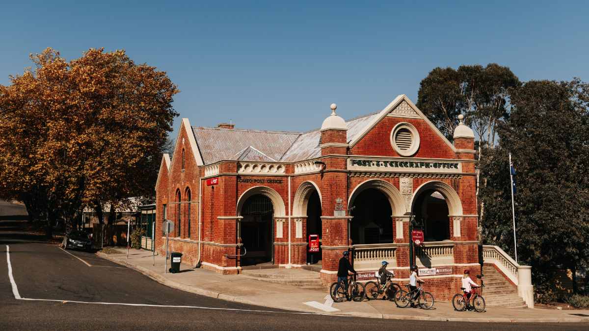
Omeo
- Distance: 44km
- Time: 40 minute drive
Descending from the alpine plateau, the road winds into the charming and historic town of Omeo. Once a booming gold mining centre, Omeo retains much of its heritage charm, with well-preserved buildings and an inviting country feel.
Explore the Omeo Historic Park & Museum to see artefacts on the earliest law and order rulings in Victoria post-settlement. The Oriental Claims Historic Area is another must-do, with several walking tracks exploring remnants of Omeo's gold-sluicing operation days.
After an adventure? Hop on a whitewater rafting journey on river sections near Omeo with Adventure Victoria Rafting. Or go on a jaunt through Davies Plain Drive, a multi-day 4WD track through the Alpine National Park accessible via Omeo.
Don't miss the German Cuckoo Clock Shop, a truly charming shopfront selling handcrafted cuckoo clocks: the perfect souvenir from your Great Alpine Road trip.
Bruthen
- Distance: 96km
- Time: 1 hour 15 minute drive
The last stop before reaching the coastal plains is the riverside village of Bruthen, where the Tambo River winds gently through verdant farmland on its way to the Gippsland Lakes system. Bruthen is a restful place to pause, stretch your legs and enjoy some country fare. The Fairy Dell Flora Reserve also offers a beautiful 1.4km return walk through a thick temperate rainforest.
If you're driving the Great Alpine Road in February, make sure to stop in Bruthen for the Bruthen Blues & Arts Festival, which draws visitors from across the state for its live blues music, workshops, street stalls and garage sales.
Bairnsdale
- Distance: 26km
- Time: 25 minute drive
The Great Alpine Road officially concludes in Bairnsdale, a regional centre on the edge of the Gippsland Lakes. Bairnsdale offers all the amenities of a larger town, including supermarkets, cafes and accommodation options, making it a practical endpoint or launching pad for further exploration.
Head to the Krowathunkooloong Keeping Place first, a museum of Aboriginal East Gippsland art and artefacts, to better understand the region. Then head to the Den of Nargun in the Mitchell River National Park. A 3.4km circuit walk leads from a picnic area through a rainforest gully down to the Den, which tradition says is the home of the Nargun: a fierce half-human/half-stone being.
The Lakes National Park is also near Bairnsdale, offering lovely nature escapes like the Lake Reeve Nature Trail (1km loop) through important wetlands for migratory birds, or the 90 Mile Beach Walk (3.8km return) out to the famous Gippsland beach. You can also catch the five-minute ferry (for both pedestrians and vehicles) out to Raymond Island for swimming beaches and a lakeside boardwalk.
Check whether the Howitt Park Market is on during your stay, with around 150 stalls hawking their wares every month. If travelling in June/July, research the East Gippsland Winter Festival, which celebrates the region's food, music, art, culture and nature, to see which events are on near you.
Omeo is a charming heritage town. Image: Visit Victoria
Safe driving tips for Victoria's Great Alpine Road
It's important to drive carefully on the Great Alpine Road. The route includes steep gradients, tight corners and changing weather. Watch for wildlife at dawn and dusk - it's common for kangaroos, wombats and deer to frequent the area.
Make sure to fuel up before leaving major towns, as some stretches of the road (e.g. Harrietville to Omeo) have limited refuelling options.
During Victoria's official snow season (from the King's Birthday long weekend to the first weekend of October), all vehicles entering alpine resorts are required to carry snow chains and to use them as directed (either by signage or an authorised officer). This direction applies to 2WD, 4WD and AWD vehicles.
Most resorts further specify that diamond-pattern snow chains must be used.
Snow chains are required for your safety and the safety of others, with substantial fines for non-compliance. Alpine resorts can refuse entry to any vehicle not fitted with chains. Fit your chains if necessary at the designated chain bays marked by a 'Fit Chains Here' sign.

